Wednesday, May 29, 2013

Mount Vesuvius


Mount Vesuvius (Italian: Monte Vesuvio, Latin: Mons Vesuvius) is a stratovolcano in the Gulf of Naples, Italy, about 9 kilometres (5.6 mi) east of Naples and a short distance from the shore. It is one of several volcanoes which form the Campanian volcanic arc. Vesuvius consists of a large cone partially encircled by the steep rim of a summit caldera caused by the collapse of an earlier and originally much higher structure.
Mount Vesuvius is best known for its eruption in AD 79 that led to the burying and destruction of the Roman cities of Pompeii and Herculaneum. That eruption ejected a cloud of stones, ash and fumes to a height of 20.5 miles, spewing molten rock and pulverized pumice at the rate of 1.5 million tons per second, ultimately releasing a hundred thousand times the thermal energy released by the Hiroshima bombing. An estimated 16,000 people died due to hydrothermal pyroclastic flows. The only surviving eyewitness account of the event consists of two letters by Pliny the Younger to the historian Tacitus.
Vesuvius has erupted many times since and is the only volcano on the European mainland to have erupted within the last hundred years. Today, it is regarded as one of the most dangerous volcanoes in the world because of the population of 3,000,000 people living nearby and its tendency towards explosive (Plinian) eruptions. It is the most densely populated volcanic region in the world.

Mythology
Vesuvius has a long historic and literary tradition. It was considered a divinity of the Genius type at the time of the eruption of 79 AD: it appears under the inscribed name Vesuvius as a serpent in the decorative frescos of many lararia, or household shrines, surviving from Pompeii. An inscription from Capua[5] to IOVI VESVVIO indicates that he was worshipped as a power of Jupiter; that is, Jupiter Vesuvius.[6]

The historian Diodorus Siculus relates a tradition that Hercules, in the performance of his labors, passed through the country of nearby Cumae on his way to Sicily and found there a place called "the Phlegraean Plain" (phlegraion pedion, "plain of fire"), "from a hill which anciently vomited out fire ... now called Vesuvius."[7] It was inhabited by bandits, "the sons of the Earth," who were giants. With the assistance of the gods he pacified the region and went on. The facts behind the tradition, if any, remain unknown, as does whether Herculaneum was named after it. An epigram by the poet Martial in 88 AD suggests that both Venus, patroness of Pompeii, and Hercules were worshipped in the region devastated by the eruption of 79. Whether Hercules was ever considered some sort of patron of the volcano itself is debatable.

Origin of the name

Vesuvius was a name of the volcano in frequent use by the authors of the late Roman Republic and the early Roman Empire. Its collateral forms were Vesaevus, Vesevus, Vesbius and Vesvius. Writers in ancient Greek used Οὐεσούιον or Οὐεσούιος. Many scholars since then have offered an etymology. As peoples of varying ethnicity and language occupied Campania in the Roman Iron Age, the etymology depends to a large degree on the presumption of what language was spoken there at the time. Naples was settled by Greeks, as the name Nea-polis, "New City", testifies. The Oscans, a native Italic people, lived in the countryside. The Latins also competed for the occupation of Campania. Etruscan settlements were in the vicinity. Other peoples of unknown provenance are said to have been there at some time by various ancient authors.

On the presumption that the language is Greek, Vesuvius might be a Latinization of the negative οὔ (ve) prefixed to a root from or related to the Greek word σβέννυμι = "I quench", in the sense of "unquenchable". In another derivation it might be from ἕω "hurl" and βίη "violence", "hurling violence", *vesbia, taking advantage of the collateral form.

Some other theories about its origin are:
From an Indo-European root, *eus- < *ewes- < *(a)wes-, "shine" sense "the one who lightens", through Latin or Oscan.
From an Indo-European root *wes = "hearth" (compare e.g. Vesta)

Physical appearance
A view of the crater wall of Vesuvius, with the
 city of Torre del Greco in the background


Vesuvius is a distinctive "humpbacked" mountain, consisting of a large cone (Gran Cono) partially encircled by the steep rim of a summit caldera caused by the collapse of an earlier and originally much higher structure called Monte Somma. The Gran Cono was produced during the eruption of AD 79. For this reason, the volcano is also called Somma-Vesuvius or Somma-Vesuvio.

The caldera started forming during an eruption around 17,000 (or 18,300) years ago and was enlarged by later paroxysmal eruptions ending in the one of AD 79. This structure has given its name to the term "somma volcano", which describes any volcano with a summit caldera surrounding a newer cone.
The height of the main cone has been constantly changed by eruptions but is 1,281 m (4,203 ft) at present. Monte Somma is 1,149 m (3,770 ft) high, separated from the main cone by the valley of Atrio di Cavallo, which is some 5 km (3.1 mi) long. The slopes of the mountain are scarred by lava flows but are heavily vegetated, with scrub and forest at higher altitudes andvineyards lower down. Vesuvius is still regarded as an active volcano, although its current activity produces little more than steam from vents at the bottom of the crater. Vesuvius is a stratovolcano at the convergent boundary where the African Plate is being subducted beneath the Eurasian Plate. Layers of lava, scoria, volcanic ash, and pumice make up the mountain. Their mineralogy is variable, but generally silica-undersaturated and rich in potassium, with phonolite produced in the more explosive eruptions.

Formation
Vesuvius was formed as a result of the collision of two tectonic plates, the African and the Eurasian. The former was subducted beneath the latter, deeper into the earth. As the water-saturated sediments of the oceanic African plate were pushed to hotter depths in the earth, the water boiled off and caused the melting point of the upper mantle to drop enough to create partial melting of the rocks. Because magma is less dense than the solid rock around it, it was pushed upward. Finding a weak place at the Earth's surface it broke through, producing the volcano.
The volcano is one of several which form the Campanian volcanic arc. Others include Campi Flegrei, a large caldera a few kilometres to the north west, Mount Epomeo, 20 kilometres (12 mi) to the west on the island of Ischia, and several undersea volcanoes to the south. The arc forms the southern end of a larger chain of volcanoes produced by the subduction process described above, which extends northwest along the length of Italy as far as Monte Amiata in Southern Tuscany. Vesuvius is the only one to have erupted within recent history, although some of the others have erupted within the last few hundred years. Many are either extinct or have not erupted for tens of thousands of years.
Mount Vesuvius has erupted many times. The famous eruption in 79 AD was preceded by numerous others in prehistory, including at least three significantly larger ones, the best known being the Avellino eruption around 1800 BC which engulfed several Bronze Age settlements. Since 79 AD, the volcano has also erupted repeatedly, in 172, 203, 222, possibly 303, 379, 472, 512, 536, 685, 787, around 860, around 900, 968, 991, 999, 1006, 1037, 1049, around 1073, 1139, 1150, and there may have been eruptions in 1270, 1347, and 1500. The volcano erupted again in 1631, six times in the 18th century, eight times in the 19th century (notably in 1872), and in 1906, 1929, and 1944. There has been no eruption since 1944, and none of the post-79 eruptions were as large or destructive as the Pompeian one.

The eruptions vary greatly in severity but are characterized by explosive outbursts of the kind dubbed Plinian after Pliny the Younger, a Roman writer who published a detailed description of the 79 AD eruption, including his uncle's death. On occasion, eruptions from Vesuvius have been so large that the whole of southern Europe has been blanketed by ash; in 472 and 1631, Vesuvian ash fell on Constantinople (Istanbul), over 1,200 kilometres (750 mi) away. A few times since 1944, landslides in the crater have raised clouds of ash dust, raising false alarms of an eruption.

Before AD 79
Scientific knowledge of the geologic history of Vesuvius comes from core samples taken from a 2,000 m (6,600 ft) plus bore hole on the flanks of the volcano, extending into Mesozoic rock. Cores were dated by potassium-argon and argon-argon dating. The mountain started forming 25,000 years ago. Although the area has been subject to volcanic activity for at least 400,000 years, the lowest layer of eruption material from the Somma mountain lies on top of the 34,000 year-old Campanian Ignimbrite produced by the Campi Flegrei complex, and was the product of the Codola plinian eruption 25,000 years ago.
It was then built up by a series of lava flows, with some smaller explosive eruptions interspersed between them. However, the style of eruption changed around 19,000 years ago to a sequence of large explosive plinian eruptions, of which the 79 AD one was the last. The eruptions are named after the tephra deposits produced by them, which in turn are named after the location where the deposits were first identified:
The Basal Pumice (Pomici di Base) eruption, 18,300 years ago, VEI 6, saw the original formation of the Somma caldera. The eruption was followed by a period of much less violent, lava producing eruptions.
The Green Pumice (Pomici Verdoline) eruption, 16,000 years ago, VEI 5. The Mercato eruption (Pomici di Mercato) — also known as Pomici Gemelle or Pomici Ottaviano — 8000 years ago, VEI 6, followed a smaller explosive eruption around 11,000 years ago (called the Lagno Amendolare eruption). The Avellino eruption (Pomici di Avellino), 3800 years ago, VEI 5, followed two smaller explosive eruptions around 5,000 years ago. The Avellino eruption vent was apparently 2 km west of the current crater, and the eruption destroyed several Bronze Age settlements of the Apennine culture. Several carbon dates on wood and bone offer a range of possible dates of about 500 years in the mid-2nd millennium BC. In May 2001 near Nola Italian archaeologists using the technique of filling every cavity with plaster or substitute compound recovered some remarkably well-preserved forms of perishable objects, such as fence rails, a bucket and especially in the vicinity thousands of human footprints pointing into the Apennines to the north. The settlement had huts, pots, and goats. The residents had hastily abandoned the village, leaving it to be buried under pumice and ash in much the same way that Pompeii was later preserved. Pyroclastic surge deposits were distributed to the northwest of the vent, travelling as far as 15 km (9.3 mi) from it, and lie up to 3 m (9.8 ft) deep in the area now occupied by Naples.

The volcano then entered a stage of more frequent, but less violent, eruptions until the most recent Plinian eruption, which destroyed Pompeii. The last of these may have been in 217 BC. There were earthquakes in Italy during that year and the sun was reported as being dimmed by a haze or dry fog. Plutarch wrote of the sky being on fire near Naples and Silius Italicusmentioned in his epic poem Punica that Vesuvius had thundered and produced flames worthy of Mount Etna in that year, although both authors were writing around 250 years later. Greenland ice core samples of around that period show relatively high acidity, which is assumed to have been caused by atmospheric hydrogen sulfide.

Fresco of Bacchus andAgathodaemon
 with Mount Vesuvius, as seen in
 Pompeii's House of the Centenary
.The mountain was then quiet for hundreds of years and was described by Roman writers as having been covered with gardens and vineyards, except at the top which was craggy. Within a large circle of nearly perpendicular cliffs was a flat space large enough for the encampment of the army of the rebel gladiator Spartacus in 73 BC. This area was doubtless a crater. The mountain may have had only one summit at that time, judging by a wall painting, "Bacchus and Vesuvius", found in a Pompeiian house, the House of the Centenary (Casa del Centenario).

Several surviving works written over the 200 years preceding the 79 AD eruption describe the mountain as having had a volcanic nature, although Pliny the Elder did not depict the mountain in this way in his Naturalis Historia:
The Greek historian Strabo (ca 63 BC–AD 24) described the mountain in Book V, Chapter 4 of his Geographica as having a predominantly flat, barren summit covered with sooty, ash-coloured rocks and suggested that it might once have had "craters of fire". He also perceptively suggested that the fertility of the surrounding slopes may be due to volcanic activity, as at Mount Etna.
In Book II of De Architectura, the architect Vitruvius (ca 80-70 BC -?) reported that fires had once existed abundantly below the mountain and that it had spouted fire onto the surrounding fields. He went on to describe Pompeiian pumice as having been burnt from another species of stone.
Diodorus Siculus (ca 90 BC–ca 30 BC), another Greek writer, wrote in Book IV of his Bibliotheca Historica that the Campanian plain was called fiery (Phlegrean) because of the mountain, Vesuvius, which had spouted flame like Etna and showed signs of the fire that had burnt in ancient history.
Eruption of AD 79

Main article: Eruption of Mount Vesuvius in AD 79
In the year of 79 AD, Mount Vesuvius erupted in one of the most catastrophic and famous eruptions of all time. Historians have learned about the eruption from the eyewitness account of Pliny the Younger, a Roman administrator and poet.
Mount Vesuvius spawned a deadly cloud of stones, ash and fumes to a height of 20.5 miles, spewing molten rock and pulverized pumice at the rate of 1.5 million tons per second, ultimately releasing a hundred thousand times the thermal energy released by the Hiroshima bombing. The towns of Pompeii and Herculaneum were destroyed by pyroclastic flows and the ruins buried under dozens of feet of tephra.An estimated 16,000 people died from the eruption.

Precursors and foreshocks

Computer-generated imageryof
the eruption of Vesuvius in
BBC/Discovery Channel's
co-production Pompeii
The 79 AD eruption was preceded by a powerful earthquake seventeen years beforehand on February 5, AD 62, which caused widespread destruction around the Bay of Naples, and particularly to Pompeii. Some of the damage had still not been repaired when the volcano erupted. The deaths of 600 sheep from "tainted air" in the vicinity of Pompeii indicates that the earthquake of 62 may have been related to new activity by Vesuvius

The Romans grew accustomed to minor earth tremors in the region; the writer Pliny the Younger even wrote that they "were not particularly alarming because they are frequent in Campania". Small earthquakes started taking place on August 20, 79 becoming more frequent over the next four days, but the warnings were not recognised.

Scientific analysis of the eruption
Reconstructions of the eruption and its effects vary considerably in the details but have the same overall features. The eruption lasted two days. The morning of the first day was perceived as normal by the only eyewitness to leave a surviving document, Pliny the Younger. In the middle of the day an explosion threw up a high-altitude column from which ash began to fall, blanketing the area. Rescues and escapes occurred during this time. At some time in the night or early the next day pyroclastic flows in the close vicinity of the volcano began. Lights were seen on the mountain interpreted as fires. People as far away as Misenum fled for their lives. The flows were rapid-moving, dense and very hot, knocking down wholly or partly all structures in their path, incinerating or suffocating all population remaining there and altering the landscape, including the coastline. These were accompanied by additional light tremors and a mild tsunami in the Bay of Naples. By evening of the second day the eruption was over, leaving only haze in the atmosphere through which the sun shone weakly.
Herculaneum and other cities affected by the eruption of Mount Vesuvius.
The black cloud represents the general distribution of ash and cinder.
Modern coast lines are shown.
The latest scientific studies of the ash produced by Vesuvius reveals a multi-phase eruption. The initial major explosion produced a column of ash and pumice ranging between 15 kilometres (49,000 ft) and 30 kilometres (98,000 ft) high, which rained on Pompeii to the southeast but not on Herculaneum upwind. The chief energy supporting the column came from the escape of steam superheated by the magma, created from ground water seeping over time into the deep faults of the region.

Subsequently the cloud collapsed as the gases expanded and lost their capability to support their solid contents, releasing it as a pyroclastic surge, which reached Herculaneum but not Pompeii. Additional explosions reinstituted the column. The eruption alternated between Plinian and Peléan six times. Surges 3 and 4 are believed by the authors to have destroyed Pompeii. Surges are identified in the deposits by dune and cross-bedding formations, which are not produced by fallout.
Another study used the magnetic characteristics of over 200 samples of roof-tile and plaster fragments collected around Pompeii to estimate equilibrium temperature of the pyroclastic flow. The magnetic study revealed that on the first day of the eruption a fall of white pumice containing clastic fragments of up to 3 centimetres (1.2 in) fell for several hours. It heated the roof tiles up to 140 °C (284 °F). This period would have been the last opportunity to escape.
The collapse of the Plinian columns on the second day caused pyroclastic density currents (PDCs) that devastated Herculaneum and Pompeii. The depositional temperature of these pyroclastic surges ranged up to 300 °C (572 °F). Any population remaining in structural refuges could not have escaped, as the city was surrounded by gases of incinerating temperatures. The lowest temperatures were in rooms under collapsed roofs. These were as low as 100 °C (212 °F).

The Two Plinys
The only surviving eyewitness account of the event consists of two letters by Pliny the Younger to the historian Tacitus. Observing the first volcanic activity from Misenum across the Bay of Naples from the volcano, approximately 35 kilometres (22 mi), the elder Pliny launched a rescue fleet and went himself to the rescue of a personal friend. His nephew declined to join the party. One of the nephew's letters relates what he could discover from witnesses of his uncle's experiences. In a second letter the younger Pliny details his own observations after the departure of his uncle.
The two men saw an extraordinarily dense cloud rising rapidly above the mountain. This cloud and a request by messenger for an evacuation by sea prompted the elder Pliny to order rescue operations in which he sailed away to participate. His nephew attempted to resume a normal life, but that night a tremor awoke him and his mother, prompting them to abandon the house for the courtyard. Further tremors near dawn caused the population to abandon the village and caused wave action in the Bay of Naples.
The early light was obscured by a black cloud through which shone flashes, which Pliny likens to sheet lightning, but more extensive. The cloud obscured Point Misenum near at hand and the island of Capraia (Capri) across the bay. Fearing for their lives, the population began to call to each other and move back from the coast along the road. A rain of ash fell, causing Pliny to shake it off periodically to avoid being buried. Later that same day the ash stopped falling and the sun shone weakly through the cloud, encouraging Pliny and his mother to return to their home and wait for news of Pliny the Elder.
Pliny’s uncle Pliny the Elder was in command of the Roman fleet at Misenum, and had meanwhile decided to investigate the phenomenon at close hand in a light vessel. As the ship was preparing to leave the area, a messenger came from his friend Rectina (wife of Bassus) living on the coast near the foot of the volcano explaining that her party could only get away by sea and asking for rescue. Pliny ordered the immediate launching of the fleet galleys to the evacuation of the coast. He continued in his light ship to the rescue of
Rectina's party.He set off across the bay but in the shallows on the other side encountered thick showers of hot cinders, lumps of pumice and pieces of rock. Advised by the helmsman to turn back he stated "Fortune favors the brave" and ordered him to continue on to Stabiae (about 4.5 km from Pompeii).
Pliny and his party saw flames coming from several parts of the mountain. After staying overnight, the party was driven from the building by an accumulation of material, presumably, tephra, which threatened to block all egress. They woke Pliny, who had been napping and emitting loud snoring. They elected to take to the fields with pillows tied to their heads to protect them from rockfall. They approached the beach again but the wind prevented the ships from leaving. Pliny sat down on a sail that had been spread for him and could not rise even with assistance when his friends departed, escaping ultimately by land.
In the first letter to Tacitus, his nephew suggested that his death was due to the reaction of his weak lungs to a cloud of poisonous, sulphurous gas that wafted over the group. However, Stabiae was 16 km from the vent (roughly where the modern town of Castellammare di Stabia is situated) and his companions were apparently unaffected by the fumes, and so it is more likely that the corpulent Pliny died from some other cause, such as a stroke or heart attack. His body was found with no apparent injuries on the next day, after dispersal of the plume.

Casualties from the eruption
Pompeii, with Vesuvius towering above


Along with Pliny the Elder, the only other noble casualties of the eruption to be known by name were Agrippa (a son of the Jewish princess Drusilla and the procurator Antonius Felix) and his wife.
An estimated 16,000 citizens in the Roman vicinities of Pompeii and Herculaneum perished due to hydrothermal pyroclastic flows. By 2003, around 1,044 casts made from impressions of bodies in the ash deposits had been recovered in and around Pompeii, with the scattered bones of another 100. The remains of about 332 bodies have been found at Herculaneum (300 in arched vaults discovered in 1980). What percentage these numbers are of the total dead or the percentage of the dead to the total number at risk remain completely unknown.
Thirty-eight percent of the 1,044 were found in the ash fall deposits, the majority inside buildings. These are thought to have been killed mainly by roof collapses, with the smaller number of victims found outside of buildings probably being killed by falling roof slates or by larger rocks thrown out by the volcano. The remaining 62% of remains found at Pompeii were in the pyroclastic surge deposits, and thus were probably killed by them – probably from a combination of suffocation through ash inhalation and blast and debris thrown around. In contrast to the victims found at Herculaneum, examination of cloth, frescoes and skeletons show that it is unlikely that high temperatures were a significant cause. Herculaneum, which was much closer to the crater, was saved from tephra falls by the wind direction, but was buried under 23 metres (75 ft) of material deposited by pyroclastic surges. It is likely that most, or all, of the known victims in this town were killed by the surges.People caught on the former seashore by the first surge died of thermal shock. No boats have been found, indicating they may have been used for the earlier escape of some of the population. The rest were concentrated in arched chambers at a density of as high as 3 persons per square meter. As only 85 metres (279 ft) of the coast have been excavated, the casualties waiting to be excavated may well be as high as the thousands.

Later eruptions from the 3rd to the 19th century

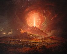
An eruption of Vesuvius seen from Portici
, by Joseph Wright (ca. 1774-6)

Since the eruption of 79 AD, Vesuvius has erupted around three dozen times. It erupted again in 203, during the lifetime of the historian Cassius Dio. In 472, it ejected such a volume of ash that ashfalls were reported as far away as Constantinople. The eruptions of 512 were so severe that those inhabiting the slopes of Vesuvius were granted exemption from taxes by Theodoric the Great, the Gothic king of Italy. Further eruptions were recorded in 787, 968, 991, 999, 1007 and 1036 with the first recorded lava flows. The volcano became quiescent at the end of the 13th century and in the following years it again became covered with gardens and vineyards as of old. Even the inside of the crater was filled with shrubbery.
Vesuvius entered a new phase in December 1631, when a major eruption buried many villages under lava flows, killing around 3,000 people. Torrents of boiling water were also ejected, adding to the devastation. Activity thereafter became almost continuous, with relatively severe eruptions occurring in 1660, 1682, 1694, 1698, 1707, 1737, 1760, 1767, 1779, 1794, 1822, 1834, 1839, 1850, 1855, 1861, 1868, 1872, 1906, 1926, 1929, and 1944.

Eruptions in the 20th century
The March 1944 eruption of Vesuvius,
by Jack Reinhardt, B-24 tailgunner
in the USAAF duringWWII

The eruption of April 7, 1906 killed over 100 people and ejected the most lava ever recorded from a Vesuvian eruption. Italian authorities were preparing to hold the 1908 Summer Olympics when Mount Vesuvius erupted, devastating the city of Naples. Funds were diverted to the reconstruction of Naples, so a new location for the Olympics was required. London was selected for the first time to hold the Games which were held at White City alongside the Franco-British Exhibition, at the time the more noteworthy event. Berlin and Milan were other candidates.
Ash is swept off the wings of an American
B-25 Mitchell medium bomber of the 340th
 Bombardment Group on March 23,
1944 after the eruption of Mount Vesuvius.


The last major eruption was in March 1944. It destroyed the villages of San Sebastiano al Vesuvio, Massa di Somma, Ottaviano, and part of San Giorgio a Cremano. From March 18 to 23, 1944, lava flows appeared within the rim. There were outflows. Small explosions then occurred until the major explosion took place on March 18, 1944.
At the time of the eruption, the United States Army Air Forces (USAAF) 340th Bombardment Group was based at Pompeii Airfield near Terzigno, Italy, just a few kilometers from the eastern base of the mountain. The tephra and hot ash damaged the fabric control surfaces, the engines, the Plexiglas windshields and the gun turrets of the 340th's B-25 Mitchell medium bombers. Estimates ranged from 78 to 88 aircraft destroyed.

The eruption could be seen from Naples. Different perspectives and the damage caused to the local villages were recorded by USAAF photographers and other personnel based nearer to the volcano.

The futureThe 1822 eruption was one of five explosive subplinian eruptions which have taken place since the 1631 eruption. The eruption column rose to about 14 kilometres (8.7 mi).
Large plinian eruptions which emit lava in quantities of about 1 cubic kilometre (0.24 cu mi), the most recent of which overwhelmed Pompeii, have happened after periods of inactivity of a few thousand years. Subplinian eruptions producing about 0.1 cubic kilometres (0.024 cu mi), such as those of 472 and 1631, have been more frequent with a few hundred years between them. Following the 1631 eruption until 1944 every few years saw a comparatively small eruption which emitted 0.001-0.01 km³ of magma. It seems that for Vesuvius the amount of magma expelled in an eruption increases very roughly linearly with the interval since the previous one, and at a rate of around 0.001 cubic kilometres (0.00024 cu mi) for each year. This gives an extremely approximate figure of 0.06 cubic kilometres (0.014 cu mi) for an eruption after 60 years of inactivity.

Magma sitting in an underground chamber for many years will start to see higher melting point constituents such as olivine crystallising out. The effect is to increase the concentration of dissolved gases (mostly steam and carbon dioxide) in the remaining liquid magma, making the subsequent eruption more violent. As gas-rich magma approaches the surface during an eruption, the huge drop inpressure caused by the reduction in weight of the overlying rock (which drops to zero at the surface) causes the gases to come out of solution, the volume of gas increasing explosively from nothing to perhaps many times that of the accompanying magma. Additionally, the removal of the lower melting point material will raise the concentration of felsic components such as silicates potentially making the magma more viscous, adding to the explosive nature of the eruption.

The government emergency plan for an eruption therefore assumes that the worst case will be an eruption of similar size and type to the 1631 VEI 4 one. In this scenario the slopes of the mountain, extending out to about 7 kilometres (4.3 mi) from the vent, may be exposed to pyroclastic flows sweeping down them, whilst much of the surrounding area could suffer from tephra falls. Because ofprevailing winds, towns to the south and east of the volcano are most at risk from this, and it is assumed that tephra accumulation exceeding 100 kg/m² – at which point people are at risk from collapsing roofs – may extend out as far as Avellino to the east or Salerno to the south east. Towards Naples, to the north west, this tephra fall hazard is assumed to extend barely past the slopes of the volcano. The specific areas actually affected by the ash cloud will depend upon the particular circumstances surrounding the eruption.

The area around the volcano is now densely populated.
The plan assumes between two weeks and 20 days' notice of an eruption and foresees the emergency evacuation of 600,000 people, almost entirely comprising all those living in the zona rossa ("red zone"), i.e. at greatest risk from pyroclastic flows. The evacuation, by trains, ferries, cars, and busesis planned to take about seven days, and the evacuees will mostly be sent to other parts of the country rather than to safe areas in the local Campaniaregion, and may have to stay away for several months. However the dilemma that would face those implementing the plan is when to start this massive evacuation, since if it is left too late then thousands could be killed, while if it is started too early then the precursors of the eruption may turn out to have been a false alarm. In 1984, 40,000 people were evacuated from the Campi Flegrei area, another volcanic complex near Naples, but no eruption occurred

Ongoing efforts are being made by the government at various levels (especially of Regione Campania) to reduce the population living in the red zone, by demolishing illegally constructed buildings, establishing a national park around the upper flanks of the volcano to prevent the erection of further buildings and by offering financial incentives to people for moving away. One of the underlying goals is to reduce the time needed to evacuate the area, over the next 20 or 30 years, to two or three days.

The volcano is closely monitored by the Osservatorio Vesuvio in Naples with extensive networks of seismic and gravimetric stations, a combination of a GPS-based geodetic array and satellite-based synthetic aperture radar to measure ground movement, and by local surveys and chemical analyses of gases emitted from fumaroles. All of this is intended to track magma rising underneath the volcano. Currently no magma has been detected within 10 km of the surface, and so the volcano is classified by the Observatory as at a Basic or Green Level.

Vesuvius today
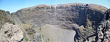
The crater of Vesuvius in 2012


The area around Vesuvius was officially declared a national park on June 5, 1995. The summit of Vesuvius is open to visitors and there is a small network of paths around the mountain that are maintained by the park authorities on weekends.

There is access by road to within 200 metres (660 ft) of the summit (measured vertically), but thereafter access is on foot only. There is a spiral walkway around the mountain from the road to the crater.

Angel Falls, Bolívar State, Venezuela


Angel Falls (Spanish: Salto Ángel; Pemon language: Kerepakupai Vená, meaning "waterfall of the deepest place", or Parakupá Vená, meaning "the fall from the highest point") is a waterfall in Venezuela. It is the world's highest uninterrupted waterfall, with a height of 979 m (3,212 ft) and a plunge of 807 m (2,648 ft). The waterfall drops over the edge of the Auyantepui mountain in the Canaima National Park (Spanish: Parque Nacional Canaima), a UNESCO World Heritage site in the Gran Sabana region of Bolívar State. The height figure 979 m (3,212 ft) mostly consists of the main plunge but also includes about 400 m (0.25 mi) of sloped cascades and rapids below the drop and a 30-metre (98 ft) high plunge downstream of the talus rapids.
The falls are on the Gauja River (alternatively known as the Kerep River or Kerepacupai), which flows into the Churun River, a tributary of the Carrao River.

Name
The waterfall has been known as the "Angel Falls" since the mid twentieth century; they are named after Jimmie Angel, a US aviator, who was the first person to fly over the falls. Angel's ashes were scattered over the falls on July 2, 1960.
The common Spanish name "Salto Ángel" derives from his surname. In 2009, President Hugo Chávez announced his intention to change the name to the purported original indigenous Pemon term ("Kerepakupai Vená", meaning "waterfall of the deepest place"), on the grounds that the nation's most famous landmark should bear an indigenous name. Explaining the name change, Chávez was reported to have said, "This is ours, long before Angel ever arrived there… this is indigenous property." However, he later said that he would not decree the change of name, but only was defending the use of Kerepakupai Vená.

Exploration  
Sir Walter Raleigh described what was possibly a tepuy (table top mountain), and he is said to have been the first European to view Angel Falls, but these claims are considered far-fetched. Some historians state that the first European to visit the waterfall was Fernando de Berrío, a Spanish explorer and governor from the 16th and 17th centuries.
According to accounts of Venezuelan explorer Ernesto Sánchez La Cruz, he spotted falls in 1912, but he did not publicize his discovery. It is possible that Cruz saw the Montoya Falls in the Sierra Pacaraima region, which are more than 500 m tall. They were not known to the outside world until American aviator Jimmie Angel flew over them on 16 November 1933 on a flight while he was searching for a valuable ore bed.
Returning on 9 October 1937, Angel tried to land his Flamingo monoplane El Río Caroní; atop Auyan-tepui, but the plane was damaged when the wheels sank into the marshy ground. Angel and his three companions, including his wife Marie, were forced to descend the tepui on foot. It took them 11 days to make their way back to civilization via the gradually sloping back side but news of their adventure spread and the waterfall was named Angel Falls in his honor. The name of waterfall - "Salto Angel" - was first published on a Venezuelan government map in December 1939.
Angel's plane remained on top of the tepuy for 33 years before being lifted out by helicopter.[citation needed] It was restored at the Aviation Museum in Maracay and now sits outdoors on the front of the airport at Ciudad Bolívar.
The first recorded person of European descent to reach the base of the falls was Latvian explorer Aleksandrs Laime, also known as Alejandro Laime to the native Pemon tribe. He reached the falls alone in 1946. He was the first to reach the upper side of falls in the late 1950ies, by climbing on the back side where the slope is not vertical. He also reached Angel's plane 18 years after the crash landing. In 18 November 1955, independence day of Latvia he announced to Venezuelan newspaper "El Nacional" that this stream without any known local name shall be called after Latvian river - Gauja. In 1955 this name was registered in National Cartographic institution of Venezuela (Dirección de Cartografía Nacional). There are no convincing proofs that indigenous Pemon people had named the local streams as Auyán-tepui was considered to be a dangerous place and was not visited by the indigenous people. However, lately the Pemon name Kerep is used as well.
Partly clouded view of Auyán-tepui and Angel Falls (centre) from Isla Raton camp, taken during the end of the dry season
Laime was also the first to clear a trail that leads from the Churun River to the base of the falls. On the way, there is a viewpoint commonly used to capture the falls in photographs. It is named Mirador Laime ("Laime's Viewpoint" in Spanish) in his honor. This trail is used now mostly for tourists, to lead them from the Isla Ratón camp to the small clearing.
The official height of the falls was determined by a survey carried out by an expedition organized and financed by American journalist Ruth Robertson on 13 May 1949. The first known attempt to climb the face of the cliff was made in 1968 during the wet season. It failed because of slippery rock. In 1969 a second attempt was made during the dry season. This attempt was thwarted by lack of water and an overhang 400 feet from the top. The first climb to the top of the cliff was completed on January 13, 1971. The climbers required nine and a half days to ascend and one and a half days to rappel down.

Tourism 
Angel Falls is one of Venezuela's top tourist attractions, though a trip to the falls is a complicated affair. The falls are located in an isolated jungle. A flight from Puerto Ordaz or Ciudad Bolívar is required to reach Canaima camp, the starting point for river trips to the base of the falls. River trips generally take place from June to December, when the rivers are deep enough for the wooden curiaras used by the Pemon guides. During the dry season (December to March) there is less water seen than in the other months (This can be clearly seen in the photos of the falls above).

The Black Forest


The Black Forest (German: Schwarzwald, pronounced [ˈʃvaʁt͡svalt]) is a wooded mountain range in Baden-Württemberg, southwestern Germany. It is bordered by the Rhine valley to the west and south. The highest peak is the Feldberg with an elevation of 1,493 metres (4,898 ft). The region is almost rectangular with a length of 160 km (99 mi) and breadth of up to 60 km (37 mi). The name Schwarzwald (German for "Black Forest") derives from the Romans who referred to the thickly forested mountains there as Silva Nigra or Silva Carbonara[citation needed] (Latin for "Black Forest") because the dense growth of conifers in the forest blocked out most of the light inside the forest.
Geology
The Black Forest consists of a cover of sandstone on top of a core of gneiss and granites. Formerly it shared tectonic evolution with the nearby Vosges Mountains. Later during the Middle Eocene a rifting period affected the area and caused formation of the Rhine graben. During the last glacial period of the Würm glaciation, the Black Forest was covered by glaciers; several tarns (or lakes) such as the Mummelsee are remains of this period.
Rivers  
Rivers in the Black Forest include the Danube (which originates in the Black Forest as the confluence of the Brigach and Breg rivers), the Enz, the Kinzig, the Murg, the Nagold, the Neckar, the Rench, and the Wiese. The Black Forest occupies part of the continental divide between the Atlantic Ocean drainage basin (drained by the Rhine) and the Black Sea drainage basin (drained by the Danube).

Feldberg
List of highest mountains

Feldberg (1,493 m (4,898 ft))
Herzogenhorn (1,415 m (4,642 ft))
Belchen (1,414 m (4,639 ft))
Spiesshorn (1,349 m (4,426 ft))
Schauinsland (1,284 m (4,213 ft))
Kandel (Berg) (1,241 m (4,072 ft))
Hochblauen (1,165 m (3,822 ft))
Hornisgrinde (1,164 m (3,819 ft))

Political jurisdiction  
Administratively, the Black Forest belongs completely to the state of Baden-Württemberg and comprises the cities of Pforzheim, Baden-Baden and Freiburg as well as the following districts (Kreise). In the north: Enz, Rastatt and Calw; in the middle: Freudenstadt, Ortenaukreis and Rottweil; in the south: Emmendingen, Schwarzwald-Baar, Breisgau-Hochschwarzwald, Lörrach and Waldshut.
Ecology and economy
The forest mostly consists of pines and firs, chiefly a mixture of the European native Norway Spruce and American imported Douglas Fir and White Pine. Some of them are grown in commercial monoculture. Similar to other forested regions, the Black Forest has had areas that were annihilated by mass logging. Due to logging and land use changes the forest proper is only a fraction of its original size and the original hardwood trees were replaced by fast-growing conifers. The cyclone Lothar downed trees on hundreds of acres of mountaintops in 1999. This left some of the high peaks and scenic hills bare, with only primary growth shrubs and young fir trees.
The main industry is tourism. In addition to the towns and monuments noted below, the Black Forest is crossed by numerous long distance footpaths, including some of the first to be established. The European long-distance path E1 crosses the Black Forest following the routes of some of the local long-distance paths. There are numerous shorter paths suitable for day walks, as well as mountain biking and cross-country skiing trails. The total network of tracks amounts to around 23,000 kilometres (14,000 mi), and is maintained and overseen by a voluntary body, the Schwarzwaldverein (Black Forest Society), which has around 90,000 members (figures from Bremke, 1999, p. 9).
Black Forest clockmakers are renowned for their precision clocks. Most of the mechanical clocks are now sold as antiquities as many factories were shut down after the First World War and the Second World War. A few factories survived the structural change.
Points of interest
There are many historic towns in the Black Forest. Popular tourist destinations include Freiburg, Calw (the birth town of Hermann Hesse), Gengenbach, Staufen, Schiltach, Haslach and Altensteig. Other popular destinations include such mountains as the Feldberg, the Belchen, the Kandel, and the Schauinsland; the Titisee and Schluchsee lakes; the All Saints Waterfalls; the Triberg Waterfalls, not the highest, but the most famous waterfalls in Germany; and the gorge of the River Wutach.
The Black Forest Open Air Museum is an open-air museum that shows the life of sixteenth or seventeenth century farmers in the region, featuring a number of reconstructed Black Forest farms. The German Clock Museum in Furtwangen portrays the history of the clock industry and of watchmakers.
For drivers, the main route through the region is the fast A 5 (E35) motorway, but a variety of signposted scenic routes such as the Schwarzwaldhochstraße (60 km (37 mi), Baden-Baden to Freudenstadt), Schwarzwald Tälerstraße (100 km (62 mi), the Murg and Kinzig valleys) or Badische Weinstraße (Baden Wine Street, 160 km (99 mi), a wine route from Baden-Baden to Weil am Rhein) offers calmer driving along high roads. The last is a picturesque trip starting in the south of the Black Forest going north and includes numerous old wineries and tiny villages. Another, more specialized route is the German Clock Route (Deutsche Uhrenstraße), a circular route which traces the horological history of the region.
Due to the rich mining history dating from medieval times (the Black Forest was one of the most important mining regions of Europe circa 1100) there are many mines re-opened to the public. Such mines may be visited in the Kinzig valley, the Suggental, the Muenster valley, and around Todtmoos.
The Black Forest was visited on several occasions by Count Otto von Bismarck during his years as Prussian and later German chancellor (1862-1890). Allegedly, he especially was interested in the Triberg Waterfalls. There is now a monument in Triberg dedicated to Bismarck, who apparently enjoyed the tranquility of the region as an escape from his day-to-day political duties in Berlin.
Fauna  
In addition to the expected kinds of wildlife to be found in a European forest area, the following types of animals may be observed in the Black Forest. Some of these animals include
Winter on Schauinsland: famous "Windbuchen"
 Beeches bent by the wind
Cattle: The Black Forest cattle belong to the rare breed of Hinterwald cattle.
The giant earthworm Lumbricus badensis is found only in the Black Forest region.
Black Forest Horses are a breed of horse, previously indispensable for heavy field work.
In some regions of the Black Forest, the Western Capercaillie can be found.
Culture
Dialects spoken in the Black Forest area are Alemannic and Swabian.
Fasnet  
The German holiday of Fastnacht, or Fasnet, as it is known in the Black Forest region, occurs in the time leading up to Lent. On Fasnetmendig, or the Monday before Ash Wednesday, crowds of people line the streets, wearing wooden, mostly hand-carved masks. One prominent style of mask is called the Black Forest Style, originating from the Black Forest Region.
Crafts  
Wood-carving is a traditional cottage industry in the region and carved ornaments now are produced in substantial numbers as souvenirs for tourists. Cuckoo clocks are a popular example; they have been made in the region since the early eighteenth century and much of their development occurred there.
In the past singing bird boxes were produced as well.
Culinary  
Black Forest ham originated from this region, and so, by name and reputation at least, did the Black Forest Cake. It also is known as the "Black Forest Cherry Cake" or "Black Forest Gateau" and is made with
chocolate cake, cream, sour cherries and Kirsch. The Black Forest variety of Flammkuchen is a Badisch specialty made with ham, cheese and cream. Pfannkuchen, a crêpe or crêpe-like (Eierkuchen or Palatschinken) pastry, is also common. The Black Forest is also known for its long tradition in gourmet cuisine. No fewer than 17 Michelin starred restaurants are located in the region, among them two restaurants with 3 stars (Restaurants Bareiss and Schwarzwaldstube in Baiersbronn)[7] as well as the only restaurant in Germany that has been awarded a Michelin star every year since 1966. At Schwarzwald Hotel Adler in Häusern, three generations of chefs from the same family have defended the award from the first year the Michelin guide selected restaurants in Germany until today.

Saturday, May 18, 2013

Milford Sound


From Wikipedia, the free encyclopedia
Milford Sound (Piopiotahi in Māori) is a fjord in the south west of New Zealand's South Island, within Fiordland National Park, Piopiotahi (Milford Sound) Marine Reserve, and the Te Wahipounamu World Heritage site. It has been judged the world's top travel destination in an international survey (the 2008 Travelers' Choice Destinations Awards by TripAdvisor)[1][2] and is acclaimed as New Zealand's most famous tourist destination.[3] Rudyard Kipling had previously called it the eighth Wonder of the World.[4]

Etymology
Milford Sound is named after Milford Haven in Wales, while the Cleddau River which flows into the sound is also named for its Welsh namesake. The Māori named the sound Piopiotahi after the thrush-like piopio bird, now extinct. Piopiotahi means "a single piopio", harking back to the legend of Māui trying to win immortality for mankind - when Maui died in the attempt, a piopio was said to have flown here in mourning.[5]

Geography
Milford Sound runs 15 kilometres inland from the Tasman Sea at Dale Point - the mouth of the fiord - and is surrounded by sheer rock faces that rise 1,200 metres (3,900 ft) or more on either side. Among the peaks are The Elephant at 1,517 metres (4,977 ft), said to resemble an elephant's head,[6] and The Lion, 1,302 metres (4,272 ft), in the shape of a crouching lion.[7]
Milford Sound sports two permanent waterfalls all year round, Lady Bowen Falls and Stirling Falls.[8] After heavy rain however, many hundreds of temporary waterfalls can be seen running down the steep sided rock faces that line the fiord. They are fed by rain water drenched moss and will last a few days at most once the rain stops.

Climate
With a mean annual rainfall of 6,813 mm (268 in) on 182 days a year,[9] a high level even for the West Coast, Milford Sound is known as the wettest inhabited place in New Zealand and one of the wettest in the world. Rainfall can reach 250 mm (10 in) during a span of 24 hours.[10] The rainfall creates dozens of temporary waterfalls (as well as a number of major, more permanent ones) cascading down the cliff faces, some reaching a thousand metres in length. Smaller falls from such heights may never reach the bottom of the sound, drifting away in the wind.
Accumulated rainwater can, at times, cause portions of the rain forest to lose their grip on the sheer cliff faces, resulting in tree avalanches into the sound. The regrowth of the rain forest after these avalanches can be seen in several locations along the sound.

Wildlife
Lush rain forests cling precariously to these cliffs, while seals, penguins, and dolphins frequent the waters and whales can be seen sometimes. The sound has been identified as an Important Bird Area by BirdLife International because it is a breeding site for Fiordland Penguins.[12]

History
The fjord was a playground[citation needed] for local Maori who had acquired a large amount of local marine knowledge including tidal patterns and fish feeding patterns over generations prior to European arrival. The fjord remained undiscovered by Europeans until Captain John Grono discovered it c.1812 and named it Milford Haven after his homeland in Wales. Captain John Lort Stokes later renamed Milford Haven as Milford Sound.[13]Milford Sound was initially overlooked by European explorers, because its narrow entry did not appear to lead into such large interior bays. Sailing ship captains such as James Cook, who bypassed Milford Sound on his journeys for just this reason, also feared venturing too close to the steep mountainsides, afraid that wind conditions would prevent escape (this refers to Doubtful Sound, so named as Cook thought it doubtful he would escape if he sailed in).[citation needed] While Fiordland as such remained one of the least-explored areas of New Zealand up to the 20th century, Milford Sound's natural beauty soon attracted national and international renown, and led to the discovery of the Mackinnon Pass in 1888, soon to become a part of the new Milford Track, an early walking tourism trail. In the same year, the low watershed saddle between the Hollyford River and the Cleddau River was discovered, where the Homer Tunnel was to be developed about sixty years later to provide road access.[14] As of the 2006 census, just 120 people lived in Milford Sound,[15] most of them working in tourism or conservation.

Tourism 
The beauty of this landscape draws thousands of visitors each day, with between 550,000 and 1 million visitors in total per year.[15][16] This makes the sound one of New Zealand's most-visited tourist spots, and also the most famous New Zealand tourist destination,[3] even with its remote location and the long journey from the nearest population centres. Almost all tourists going to the sound also take one of the boat tours which usually last one to two hours. They are offered by several companies, departing from the Milford Sound Visitors' Centre. There is also the option of extended overnight cruises on Milford Sound.Overview Tramping, canoeing, and some other water sports are possible. A small number of companies also provide overnight boat trips. There is otherwise only limited accommodation at the sound, and only a very small percentage of tourists stay more than the day. Many tourists visiting Milford Sound usually stay in Te Anau to the south or Queenstown to the east.
An underwater tourist observatory found in one of the bays of the sound provides viewing of black coral, usually only found in much deeper waters. A dark surface layer of fresh water, stained by tannins from the surrounding forest, allows the corals to grow close to the surface here.[17]
In rainy and stormy days tourists can admire the play of the wind with the numerous waterfalls in Milford Sound. When meeting the cliff face the powerful wind often goes upward and waterfalls with a vertical drop get caught by wind, causing the water to go upwards.

Transport
Main article: Transport in Milford Sound
By road, Milford Sound is 307 km from Queenstown and 279 km from Invercargill (about four hours' drive),[18] with most of the tour buses to the sound departing from Queenstown. Some tourists also arrive from the smaller tourism centre of Te Anau, 121 km away. There are also scenic flights by light aircraft and helicopter tours to and from Milford Sound Airport. The drive to Milford Sound itself passes through unspoiled mountain landscapes before entering the 1.2 km Homer Tunnel which emerges into rain-forest-carpeted canyons that descend to the sound. The winding mountain road, while of high standards, is very prone to avalanches and closures during the winter half of the year.
The long distance to the sound means that tourist operators from Queenstown all depart very early in the day, arriving back only late in the evening. This ensures that most tourists visit Milford Sound within a few hours around midday, leading to some congestion on the roads and at the tourist facilities during the main season. The peak-time demand is also the reason for the large number of tour boats active in the sound at much the same time.[16]
Over the years, various options of shortening the distance to Milford Sound from Queenstown have been mooted, including a gondola route, a new tunnel from Queenstown, or a monorail from near Lake Wakatipu to Te Anau Downs. All would reduce the current round-trip duration (which has to travel via Te Anau), thus allowing tourism to be spread out over more of the day. While a gondola is considered to be out of the running after the DOC declined approval for environmental reasons, the tunnel and the monorail proposals have applied to the Department of Conservation for concessions for land access.[16]

El Yunque National Forest


El Yunque National Forest, formerly known as the Luquillo National Forest and the Caribbean National Forest,[2] is a forest located in northeastern Puerto Rico. It is the only tropical rain forest in the United States National Forest System. The forest is commonly known as El Yunque, which may be attributed to either a Spanish approximation of the aboriginal Taíno word yu-ke which means "white lands", or the word "anvil," which is yunque in Spanish. The second-tallest mountain within El Yunque is also named El Yunque. El Yunque
National Rainforest is located on the slopes of the Sierra de Luquillo mountains and it encompasses 28,000 acres (43.753 mi² or 113.32 km²) of land, making it the largest block of public land in Puerto Rico. El Toro, the highest mountain peak in the forest rises 1,065 metres (3,494 ft) above sea level. Ample rainfall (over 200 inches a year in some areas) creates a jungle-like setting — lush foliage, crags, waterfalls and rivers are a prevalent sight. The forest has a number of trails from which the jungle-like territory's flora and fauna can be appreciated. El Yunque is also renowned for its unique Taíno petroglyphs.

Melissani Lake


Melissani Lake, as the name suggests, is a nice lake with boats. But this lake is inside a cave. The cavern, once two big chambers, caved in several thousand years ago. Today the cave has the shape of a B, with two big water filled halls and an island in the middle. The first hall has a big oval opening to the surface, where the sunlight shines in. When the sun is directly overhead, its rays strike the ultramarine water, lighting the cave with blue light. So the best time to visit the cave is on a sunny day at the middle of the day. Nevertheless, a visit at the morning or in the evening has its own atmosphere. The boats seem to hover on a lake of blue light.
Image: the pier is still in the shadow, early in the morning.
The cave is entered through an tunnel, which ends at a very small pier. The boats are on the lake all the time, waiting for visitors. When visitors arrive at the pier, one of the boats lands and lets them to embark.
The complete tour is done by boat, first making a round trip around the first hall with the hole in the roof. Then the boat passes the island on the opposite wall, where a small channel exists. This channel is too narrow to row, but there is a rope at the wall and the gondolier pulls the boat through. The second hall is a huge cavern with an arched roof, which was also formed by a collapse, but this cave is more to center of the island, and because of the slope of the hill, the overlying rock is still thick enough. Now it seems the ceiling has come to an end, it forms a pretty perfect dome which should be rather stable.
Image: the second chamber, behind the central island.
The second chamber has numerous big stalactites which are green from algae and moss. With the daylight coming in, this is not a big surprise. And despite their size, they look minute in the big dome. This chamber is lit with electric light, unfortunatley only yellow lamps, rather typical for Greek caves and giving this part of the cave a sick look.
The island is not visited during a tour. There are some stalagmites, but they are also green and unimposing. But the island is rather interesting for the archaeological remains found here. During the first exploration in 1951, an ancient lamp, which is now on display in the Archaeological Museum of Argostoli, was found there.
The excavations of 1962 were made by S. Marinos and produced few but important relics of a former Minoan culture on Cephalonia. Oil lamps, plates and figures show the god Pan and several nymphs. This is, why the cave is sometimes called Cave of the Nymphs, but this is a bit confusing, as there are dozens of nymph caves in Greece. However, the lake was named after one of the nymphs, the nymph Melissanthi.
An artificial balcony offers an enchanting view from the top of the cave. Unfortunately this balcony is now closed to the public. The hole was fenced rather freehandedly, including the balcony and so there is now no chance see the cave despite the cave visit. Knowing a bit about the intensive Greek urge for security measures, we suppose financial interests behind this fence. The cave trip is the most expensive of all Greek caves reviewed, especially if the tip for the gondolier is included.

Lake Melissani has an absolute invisible specialty, which sounds pretty strange. The lake water is brackish, a mixture of sea water and sweet water. The cave is about 500m from the sea, and the water level is a metre higher than sea level, and the brackish water rises from a 30m deep cave system on one side of the cave and flows silently to the other end of the cave, flowing through narrow crivices into the sea.
Here the water from the  Katavothres on the other side of the Island reappears. This was discovered by dye tracing experiments in 1959. For a detailed explanation of this unique geological structure, have a look at the  Katavothres page.

Wednesday, May 15, 2013

Andaman Nicobar Islands


Andaman & Nicobar Islands are blessed with a unique tropical rainforest canopy, made of a mixed flora with elements from Indian, Myanmarese, Malaysian and endemic floral strains. So far, about 2,200 varieties of plants have been recorded, out of which 200 are endemic and 1,300 do not occur in mainland India.
The South Andaman forests have a profuse growth of epiphytic vegetation, mostly ferns and orchids. The Middle Andamans harbours mostly moist deciduous forests. North Andamans is characterized by the wet evergreen type, with plenty of woody climbers. The North Nicobar Islands (including Car Nicobar and Battimalv) are marked by the complete absence of evergreen forests, while such forests form the dominant vegetation in the central and southern islands of the Nicobar group. Grasslands occur only in the Nicobars, and while deciduous forests are common in the Andamans, they are almost absent in the Nicobars. The present forest coverage is claimed to be 86.2% of the total land area.
This atypical forest coverage is made up of twelve types, namely:
  • Giant evergreen forest
  • Andamans tropical evergreen forest
  • Southern hilltop tropical evergreen forest
  • Cane brakes
  • Wet bamboo brakes
  • Andamans semi-evergreen forest
  • Andamans moist deciduous forest
  • Andamans secondary moist deciduous forest
  • Littoral forest
  • Mangrove forest
  • Brackish water mixed forest
  • Submontane hill valley swamp forest

This tropical rain forest despite its isolation from adjacent land masses is surprisingly rich with a diversity of animal life.
About 50 varieties of forest mammals are found to occur in the Andaman and Nicobar Islands. Some are endemic, including the Andaman Wild Boar. Rodents are the largest group with 26 species, followed by 14 species of bat. Among the larger mammals there are two endemic[citation needed] varieties of wild boar, Sus scrofa andamanensis from Andaman and Sus scrofa nicobaricus from Nicobar, which are protected by the Wildlife Protection Act 1972 (Sch I). Saltwater crocodile is also found in abundance. The State animal of andaman is dug-ong also known as sea cow which can be found in little andaman. Around 1962 there was an attempt to introduce the leopard, which was unsuccessful because of unsuitable habitat. These were ill-considered moves as exotic introductions can cause havoc to island flora and fauna.
About 270 species of birds are found in the territory; 14 of them are endemic, the majority to the Nicobar island group. The islands' many caves are nesting grounds for the Edible-nest Swiftlet, whose nests are prized in China for bird's nest soup.[15]
The territory is home to about 225 species of butterflies and moths, including some of the larger and most spectacular of the world. Ten species are endemic to these Islands. Mount Harriet National Park is one of the richest areas of butterfly and moth diversity on these Islands.
The islands are well known for of prized shellfishs, especially from the genera Turbo, Trochus, Murex and Nautilus. Earliest recorded commercial exploitation began during 1929. Many cottage industries produce a range of decorative shell items. Giant clams, green mussels and oysters support edible shellfishery. The shells of scallops, clams, and cockle are burnt in kilns to produce edible lime.